How to Read a Hiking Trail Like an Experienced Hiker
Learn to read a hiking trail using blazes, markers, signs, and terrain clues before small navigation errors escalate.
TL;DR
- Learning to read a hiking trail goes beyond following visible signs and blazes.
- Surface shifts, contour changes, and terrain features offer early clues.
- Trail markers and trail signs confirm direction but should not replace judgment.
- A trail map or topographic map adds context from trailhead to summit.
- Environmental awareness reduces small route-finding errors before they escalate.
From Following a Hiking Trail to Learning How to Read It
Most hikers begin by following a trail. They look for the next sign, the next blaze, or the next marker placed at eye level along the path. That approach works — until subtle terrain changes or faint side routes begin to blur direction.
Learning to read a hiking trail means understanding how trails are typically marked, how trail blazes are used to indicate direction, and how terrain features confirm what a trail marker suggests. Experienced hikers combine map reading with observation. They notice slope changes, drainage lines, and contour shifts long before they become unstable.
A trail map or topographic map does not replace awareness — it supports it. Whether using a paper map, AllTrails, or tools like Google Earth, knowing how to read terrain from trailhead to summit strengthens judgment.
This guide builds on our broader article on hiking decision making and trail intelligence, focusing specifically on reading trail signs, trail markers, and environmental clues in real time.
When you shift from simply following a hiking trail to interpreting it, route-finding becomes more intuitive and controlled.
What It Means to Read a Hiking Trail Instead of Just Following It
Reading a hiking trail means recognizing environmental clues before a sign or blaze confirms them. Many hikers rely on trail markers alone, scanning ahead for paint or posts that indicate which way the trail is going. Experienced hikers do more than that. They read terrain first.
A subtle change in surface texture, a contour shift along a hillside, or a faint landmark at eye level often signals a change of direction before the next blaze appears. Trails are typically marked to guide movement, but the terrain itself provides context. When the ground begins to slope gradually or erosion alters the path, that change matters.
Knowing how to read a hiking trail also means understanding that markers may fall off or get stolen. A blaze is confirmation — not a guarantee. If a route feels inconsistent with surrounding terrain features, pause before continuing.
Strong on-trail awareness combines observation with map reading. Instead of waiting for a sign to solve uncertainty, you learn to interpret the landscape first.
That shift — from following to understanding — strengthens judgment on every hike.
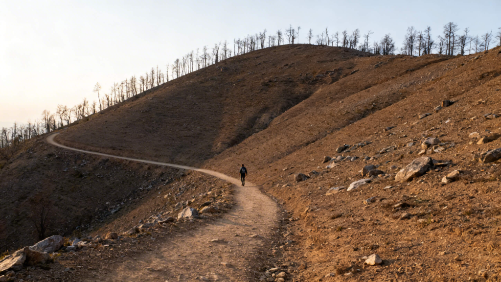
How to Spot Terrain Transitions Before They Affect Stability
Terrain rarely changes abruptly on a hike. Most shifts begin subtly — packed soil loosens, moisture collects along a contour line, or a dry section of trail transitions into shaded ground that retains water. Experienced hikers notice these small changes before footing becomes unstable.
Reading a hiking trail means anticipating where traction may decrease or where the route naturally bends around terrain features. A slight slope along a hillside can signal a change in direction long before a trail marker confirms it. Loose gravel after compact dirt is a clue. So is a sudden narrowing of the path.
During a hike, situational awareness matters most at transition points. Areas near tree line, exposed ridges, or sections that receive snow seasonally may show early surface breakdown. Even a subtle contour shift can influence balance.
Instead of reacting after slipping or losing momentum, skilled hikers pause briefly to reassess. They adjust pace, check footing, and confirm route alignment before continuing.
Small terrain shifts compound quietly. Recognizing them early strengthens judgment and reduces minor route-finding errors before they escalate.
Trail Markers, Blazes, and Signs: Reading Them Without Overreliance
Trail markers and trail blazes are used to indicate which way the trail is going, but they are not the whole story. Trails are typically marked with paint, posts, or cairns to guide hikers along a hiking trail. Understanding the common types of trail markers helps, but experienced hikers avoid depending on them alone.
Paint markers can be found at eye level on trees or rocks. In many regions, two blazes stacked vertically may signal a change of direction, such as a right turn or left turn. Trail signs at a junction often indicate distance or a spur leading to a different trail. Learning to read trail signs means confirming direction, not blindly trusting it.
Markers may fall off or get stolen. Snow, erosion, or heavy use can obscure blazes. That’s why map reading still matters. A trail map or topographic map shows contour lines and terrain features that confirm what markers suggest. Digital tools like AllTrails or Google Earth can provide context before a hike, but knowing how to read terrain on-trail remains essential.
Blazes guide. The landscape confirms.
Strong hikers use both.
Reading Changing Conditions in Real Time
Conditions rarely shift all at once during a hike. More often, subtle environmental changes signal that stability, visibility, or exposure may soon increase.
Wind direction may alter as you move along a hillside. Cloud cover can thicken gradually, affecting light and depth perception. Moisture may collect in shaded sections, softening footing even when surrounding ground appears dry. These are early clues — not dramatic warnings.
Strong situational awareness means noticing patterns before they escalate. If a dry surface becomes slick under tree cover, that change deserves attention. If a slope feels steeper than expected, pause and reassess. A small contour adjustment can affect balance more than distance suggests.
Experienced hikers treat shifting conditions as information, not interruption. Instead of reacting after slipping or overextending, they adapt pace and spacing early.
For a deeper breakdown of how to adjust when environmental variables shift, see our guide on adjusting your hiking plan when conditions change.
Environmental awareness is not about predicting every outcome. It’s about recognizing subtle signals in terrain features before they compound into instability.
How Experienced Hikers Build On-Trail Awareness Over Time
Environmental literacy does not develop overnight. It strengthens through repeated exposure to different terrain features, weather conditions, and route variables. Each outing adds reference points.
Pattern recognition is central. Over time, a hiker begins to notice how slopes typically bend around a hillside, how drainage lines influence footing, and how exposure feels before it becomes uncomfortable. These observations become internal benchmarks.
Slowing slightly at transition zones reinforces awareness. Instead of rushing through a contour shift or subtle route bend, experienced hikers pause long enough to confirm alignment with surrounding terrain. That brief reset protects judgment.
Minor errors are part of growth. Taking a wrong fork and correcting early builds confidence. Reflection afterward deepens understanding. Learning to read environmental cues becomes intuitive when you evaluate what worked and what did not.
If you are unsure whether shifting terrain warrants retreat rather than continuation, read our guide on when to turn around on a hike.
On-trail awareness compounds. Each decision improves the next.
Reading the Trail Is a Skill That Compounds
Learning how to read a hiking trail changes the way you move outdoors. You stop waiting for confirmation and begin noticing subtle contour shifts, surface changes, and environmental clues before uncertainty builds.
Trail blazes, markers, and signs exist to guide you. But experienced hikers combine those tools with terrain awareness and steady judgment. A trail map or topographic map supports observation — it does not replace it.
At Lafleur Media, Pavements to Peaks is built around helping everyday hikers grow beyond the basics through thoughtful outdoor education. Reading terrain from trailhead to summit is one of the foundational skills that separates casual movement from intentional travel.
Over time, environmental literacy becomes intuitive. Small adjustments happen earlier. Route-finding feels steadier. Confidence increases without ego.
Skill depth is not about covering more distance.
It is about seeing more — and making better calls because of it.